"El Riachuelo" - the ephemeral steep forest stream of Rimu Ridge
Thursday 16th July 2020
 |
|---|
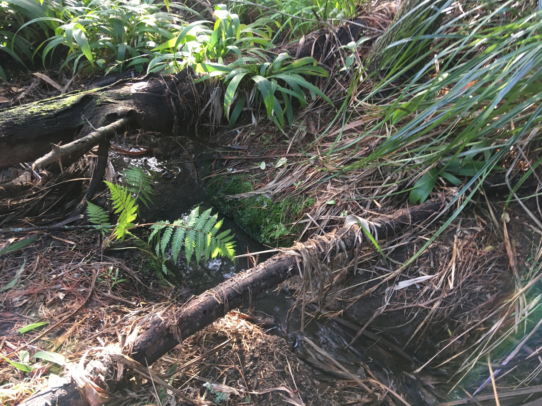
| A juvenile treefern (left) and Gahnia xanthocarpa (upper right) released from palmgrass (part of the retained portion visible at upper left) on the South (El Sitio) bank of El Riachuelo |
{UPDATE July 27
Several forays into the surrounding forest below the flooded area revealed no plant material or litter associated with recent flows. The flow seems to have been widely disseminated by fallen logs and deep pine litter, both of which will be maintained to ensure ongoing absorption here near the top of the ridge in the wet-loving plant community that has developed there.
The streamhead has been loosely covered with available dead woody vine, dead branches and cut harakeke tied into bundles. The stream channel below has been bridged at close intervals with fallen branches, and these will be covered by cut harakeke leaves, including some coarsely woven mats to allow filtered light and easy uplifting for water inspection.}
Videos 1, 2, 3, and 4 were made of the stream on Sunday 21 July, after 5mm of rain that day, and 2mm the day before (recorded by rain guage at a nearby residence).
At the dry start of an even drier summer last year, during exploratory weeding near the top of the newly-adopted forest margin at El Sitio, we were uplifted by a tiny glimpse of standing water beneath dense palmgrass under native trees recently released from honeysuckle. The small area of palmgrass removal revealed mahoe and kawakawa seedlings and a tiny fern clinging to a low wet bank. A hidden roadside drain, we thought. Or run off from recent rain somehow channelled and briefly pooled here. Half in jest, we named it: "El Riachuelo", or "The Rivulet". Like "El Sitio", the restoration area between this water and the mown grass margin, the name honours the native language of the volunteer who has adopted the care of this area.
This week, removal of much of the palmgrass foliage revealed an ephemeral first-order stream, a significant part of the urban Auckland freshwater environment.
Satellite view of the canopy development from 1960 to the present day suggests, at some time in history, two confluent streams in Gahnia Grove. The site of recent erosion by stormwater runoff, "Forest below CHF Bank," appears to be in the vicinity of the Southern of these streams, while the satellite-view suggests a Northern arm running down from the palmgrass infested area just South of the petrol station, the two streams meeting at the boardwalk of the forest path.
The manual suppression of about half the palmgrass infestation in El Sitio disclosed the head and about 10 metres of an ephemeral stream. Of low gradient and energy here at the top of the ridge, it meanders across the bank, disappearing under log dams and coarse forest debris in places, before separating into separate channels, some of seepage, some contributing to a steep forest stream below.
At its head it emerges from solid ground at the lower edge of El Sitio Top, ie about 10m within the cordoned Trial area and over 20m from the undrained roadside. Over its emergence the ground is clay, bearing mature trees and apparently stable. There is no piping, channelling or other sign of construction at the stream's emergence, though a section of plastic corrugated drain is partially embedded in the soil there, perhaps, like other construction debris and litter throughout this roadside forest margin, discarded at roadside and blown or washed down the bank.
Under the water at the bottom of the a short 2 m deep, 1 m wide channel of the stream's emergence are one or two flat slabs of rock or possibly concrete.
Today after light rain the stream is flowing gently and steadily between its banks, the ground on either side porous and superficially moist, with native tree seedlings and juveniles undisturbed. The left bank, a broad shallow slope, has evidently been uniformly flooded at some time or times between Tuesday and Thursday, throughout several metres of its breadth, to a height of about 30cm, leaving debris over a decaying long-fallen tree (wattle?) and a dozen or so suppressed palmgrass plants, among which the few native plants found were nikau seedlings and Carex lambertiana or dissita. There are no plants uprooted, either by weeding or by flooding, and the visible debris ends at the lower end of the palmgrass stand, where small hangehange, mapou, coprosma, putaputaweta and Syzygium stand several metres tall, undamaged, and the remaining palmgrass hides any debris or channel.
Beyond the palmgrass the bank slopes steeply downhill, and in places a narrow unstable channel can be seen descending it through a dense diverse mainly-native understorey partially released from honeysuckle from late 2019 on. Since the adoption of El Sitio into this Trial, the Kahili ginger dominating this understorey on adjoining banks is also being progressively reduced, but much remains.
At the stream's emergence the bank is a steep slope on both sides, the water emerging a metre or two below the bank top. A few metres downstream however, the stream banks are lower and the surrounding ground almost level. The stream remains 10-30 cm deep as it runs between shallowly undercut but stable clay banks, bordered by flat slightly spongy ground with a homogenous fine black tilth at least 10cm deep, with some substantial mahoe and putaputaweta roots in the stream channel itself. The vertical and undercut banks of the stream are moss covered and bearing juvenile ferns in some small areas where a little exploratory weeding was done in late 2019, before halting weed removal during the dry season.
As the stream turns South to meander across El Sitio Bank, a shallower branch runs straight ahead through the litter of a large radiata pine on Pohutukawa Bank. Past this pine the current becomes widespread seepage and puddles, with a thin trickle turning left to rejoin the stream on El Sitio, where it is hidden under the remaining stand of palmgrass.
Nikau seedlings and carex lambertiana/dissita and ground mats of thread fern (Blechnum filiforme) are present here wherever palmgrass is absent. (Thread fern also climbed the trees and covered the ground further uphill on the periphery of the recently flooded area until seriously declining in late summer 2020 after prolonged severe drought).
The reduction of the palmgrass infestation two days ago in El Sitio did not involve uprooting plants. Each of a dozen or so very large plants had its seedheads tucked down into its centre and its leaves broken down and pressed onto the base. These manually controlled plants are now about 30-40cm H, spaced 50-100cm apart and topped with a little flood debris.
The steep banks of the stream's emergence currently hold flood debris to about 1m above ground level on each sides of a 2m deep, or high, erosion of the clay bank, suggesting water emerges at its base, or flows over its top, with some force. There is no sign of flooding on or over this bank however, so we assume the flow is from underground, either from a broken stormwater pipe - although we understand there is no reticulation of stormwater on this side of the road - or an unformed underground channel or spring.
Assessment
There is no sign of flooding or boggy ground above the emergence, ie from the roadside to the head of the stream. Therefore we assume the stream emerges with some force and volume from an underground channel, whose source is unknown, and has supported the development of this streamside plant community for several decades. The exposed 10-15 m length of stream currently meandering across the bank irrigates the porous and humus-rich ground around a mature and a juvenile nikau, several mature, but drought-damaged, putaputaweta, several large mature pigeonwood, mapou and mahoe, which together form a thin and incomplete canopy.
There are few intact fallen nikau leaves. As the nikau is about 8m H and there are few intact nikau fronds, we assume that several decades of fallen palmgrass and nikau leaves have rotted here, with the abundant ti kouka leaf litter, in the seasonal flooding of this stream, creating the spongy, fibrous soil. Perhaps the stream also brings sediment from erosion of soils elsewhere. In any case, the vegetation seems to have been effective in filtering a good deal of water while developing and retaining a rich and absorbent soil.
Plan
Beyond the area of this week's palmgrass control and stream exposure, tree canopy is thin here. Though rawirinui and radiata pine provide tall canopy on the left and right, summer sun falls directly on this area for parts of the day, threatening dessication. The stand of palmgrass that remains here is mixed with small trees, and will be retained (with seedheads controlled) until the exposed area above has been revegetated and the stream shaded, initially by small logs and nikau fronds placed across it.
Decaying fallen and woody debris will be placed in the stream where they are likely to slow flow and create pools without being washed away.
Logs, sticks, nikau fronds, ti kouka leaves and other woody debris will be placed across the broad almost-level flood-prone bank, trapping debris, to retain maximum soil moisture for both wild and small planted seedlings to reestablish ground cover after the loss of palmgrass cover. The flood pattern will be determined by observation of the movement of this debris, and its placement adjusted for maximum debrism soil and water retention accordingly.
The many clumps of still-rooted palmgrass are continuing to slow flood flow and trap debris, and will be retained, with their foliar regrowth possibly being encouraged through next summer, to be further reduced next autumn.
Runoff patterns, flooding depths and signs of erosion will be monitored to guide further restoration.
Research for Auckland Council has determined that ephemeral steep forest streams are an important habitat for shortfin eel and banded kokopu reproduction, though adults may not survive the summers. This ephemeral stream feeds into the Kaipatiki Stream about 50m downhill. It would therefore be very helpful to know how contaminated this water is, and whether it contains life.
Pending any further advice that may be received, a provisional plan for protection of El Riachuelo's "flood plain" has been posted here.


Comments
The ground under the streamside porokaiwhiri, mahoe, mamaku and putaputaweta, despite comprehensive mulching with decaying palmgrass old and new, became increasingly dry through Spring and Summer, and no seedlings native or exotic, have emerged from the mulch or survived release from the mulch.
Many tight bundles of harakeke prunings remain across the bank, retaining ground litter in the occasional light flooding since winter, and covering much of the otherwise bare soil,while leaving gaps for seedling emergence. The ground beneath these bundles remains moist.
The few planted toatoa, Senecio eslerii, amd kawakawa, and small planted segments of Calystegia sepium roseata, have grown slowly, to a maximum of about 20cm H.
The streambanks were shaded with shadecloth in December, greatly reducing the sun invasion of this area, particularly the hot sun of the afternoon on this West-facing ridge top.
Juvenile and small adult native trees released from honeysuckle, and where necessary supported towards erect growth, have become taller and denser, and retain good colour in late January.
A kaihua seedling planted on the extreme stream bank, under ti kouka and mapou, is doing well.
See recent observations for descriptions of the native regeneration and ongoing weed control, both of which have been very successful so far.
@josephknightnz You may be interested in some of this, eg the videos of streamflow, and all the linked information is worth at least scanning...eg steep forest streams... as it explains some of what I was showing you and talking about.
Add a Comment